Students can design and create their own maps using resources from the Smithsonian Museums.
- Subject:
- Social Studies
- Material Type:
- Activity/Lab
- Provider:
- Smithsonian Institution
- Author:
- Smithsonian National Museum
- Date Added:
- 02/26/2019

Students can design and create their own maps using resources from the Smithsonian Museums.

In this lesson, students learn about their state as they collect, organize, analyze, map, and graph a variety of information in "State Facts for Students." Students examine data about kids their age, as well as a variety of other facts selected to appeal to young students.

In this resource, students can learn about the geography of the United States through short videos, mini-activities, and practice questions. The eight questions in this segment cover topics such as, the longest rivers in the country, the oceans that border the country, and the states that border Canada and Mexico.
This site was designed with the needs of recent immigrants in mind. It is written at a “low-intermediate†ESL level.

This Teacher Guide identifies the Civics Test questions covered in the theme, Geography. It also provides the instructional steps to familiarize teachers with the elements and navigation of the Preparing for the Oath - Geography student interactive so that they can be comfortable presenting it to their class.

The best way to learn something is to repeat, retell and teach something to others. Students will learn about events in history. They can be scientific or historical events. Students may read about them in a history book or even in a book of historical fiction.

This course was created by the Rethink Education Content Development Team. This course is aligned to the NC Standards for 3rd Grade Social Studies.

This course was created by the Rethink Education Content Development Team. This course is aligned to the NC Standards for 3rd Grade Social Studies.

Explore 14,000 years of history from the NC Museum of History' exhibit, The Story of North Carolina in 360°—one gallery at a time. Designed with the student experience in mind, each tour features artifacts, photos, & videos.

Students will find and explore a local place that is connected to trains, such as a train station, a train museum, or train tracks. This is connect with the Smithsonian Museums.

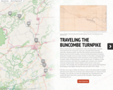
In this activity, students use a story map to follow the historic route of the Buncombe Turnpike and learn more about its economic and cultural impact on western North Carolina. Students will also see how the landscape has transformed in the nearly 200 years since the creation of the Turnpike.

In this unit, students learn that mapped patterns are analyzed and used to help solve societal problems. Students also lean that maps can be used to distort or introduce bias into the information they portray.

This inquiry engages students in exploring world geography through the compelling questions "Where are we?" This question sparks students' intellectually curiosity through the study of geographic location and the impact of humans on their environment. Working with evidence from sources, students should understand that, although we can be in different places, our impact on Earth is worth considering.

This lesson will address the physical and human characteristics of the local community. Students will build geographic vocabulary as well as use map skills.