This is a short video outlining the causes and effects of a …
This is a short video outlining the causes and effects of a magnitude 9.2 earthquake in Alaska in 1964. Additional resources include a background essay and discussion questions.
This animation illustrates how seismic waves travel through the earth to a …
This animation illustrates how seismic waves travel through the earth to a single seismic station. Scale and movement of the seismic station are greatly exaggerated to depict the relative motion recorded by the seismogram as P, S, and surface waves arrive.
This animation illustrates the movement of the three basic waves associated with …
This animation illustrates the movement of the three basic waves associated with an earthquake and the effects of these waves on various locations. By measuring the travel time of the P and S waves, distances from the epicenter can be calculated.
In this lesson, students will access Global Positioning System (GPS) data from …
In this lesson, students will access Global Positioning System (GPS) data from the Plate Boundary Observatory (PBO) and analyze the data in a spreadsheet to measure the motion of GPS stations in the Pacific Northwest. From their analyses, they will generate and map annual velocity vectors of GPS stations. Finally, they will explore patterns in the direction and length of velocity vectors on the map to understand tectonic motion and surface deformation associated with the subduction of the Juan de Fuca plate under the North American plate.
This PPT is designed to help students differentiate hotspot island chains from …
This PPT is designed to help students differentiate hotspot island chains from volcanic island arc systems. The focus sights for this activity are the Society Island hotspot chain and the Caribbean island arc system. Using map images, students are asked to describe and differentiate the topography and geologic features of the two tectonic settings. Vertical exaggeration and topographic profiles are introduced for each site. Students compare the difference in volcanism and seismicity of the two locations. This activity can be used as a lecture enhancement or as a homework or lab exercise.
Students will plot and compare actual earthquake foci data from two areas …
Students will plot and compare actual earthquake foci data from two areas where subduction is currently occurring. One of the areas includes the Tonga Islands in the southwest Pacific Ocean. The other area is along the coastline of Chile.
In this activity, students explore the difference between brittle and ductile deformation …
In this activity, students explore the difference between brittle and ductile deformation in everyday materials and how material behavior is influenced by temperature and the rate of deformation. Then, they will apply this knowledge to rocks deformation and how this is related to the occurrrence of earthquakes and mountain ranges at plate boundaries.
There are a number of hands-on and interactive scientific lesson plans, each …
There are a number of hands-on and interactive scientific lesson plans, each inviting students to learn what is known about earthquakes, earthquake hazards, and hazards preparedness. Prior to the start of lessons, it is important to assess student's knowledge of earthquakes and hazards. The pre-assessment activity creates a means to do this. Lessons 1-6 target physical processes related to earthquakes. Lessons 7-11 focus on hazards associated with earthquakes and mitigation strategies. Lesson 12 provides a unique means for reinforcing concepts covered during previous lessons.
Students conduct research about a type of natural event, learn why it …
Students conduct research about a type of natural event, learn why it occurs, where the probable locations of occurrence are, what causes damage, what conditions create especially destructive events, and what the probability of a destructive event is. It is important that students spend some time thinking about possible ways to reduce the negative impact of damaging natural events to reduce fear and increase empowerment.
Students read two descriptions of Earth's interior structure and summarize similarities and …
Students read two descriptions of Earth's interior structure and summarize similarities and differences between the two and answer a series on analysis questions.
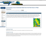
In this lesson, students examine three cross-sectional profiles from a northern, central, …
In this lesson, students examine three cross-sectional profiles from a northern, central, and southern location of the Red Sea. Students answer a series of questions reading data from the profiles, then examine images and volcanic data in Google Earth to determine the type of plate boundary located in the Red Sea and to make prediction of tectonic activity in the future.
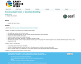
Students will use a GIS map to compare the Rocky Mountains and …
Students will use a GIS map to compare the Rocky Mountains and the Andes Mountains. They will also investigate the relationship between mountain ranges and plate boundaries.
No restrictions on your remixing, redistributing, or making derivative works. Give credit to the author, as required.
Your remixing, redistributing, or making derivatives works comes with some restrictions, including how it is shared.
Your redistributing comes with some restrictions. Do not remix or make derivative works.
Most restrictive license type. Prohibits most uses, sharing, and any changes.
Copyrighted materials, available under Fair Use and the TEACH Act for US-based educators, or other custom arrangements. Go to the resource provider to see their individual restrictions.