This parent guide supports parents in helping their child at home with …
This parent guide supports parents in helping their child at home with the 3rd grade Social Studies content. Within the folder you will access Parent Guide PDFs in FIVE Languages: Arabic, English, Hindi, Spanish, and Vietnamese to help on-going communication with caregivers.
This resource accompanies our Rethink 3rd Grade Science course. It includes ideas …
This resource accompanies our Rethink 3rd Grade Science course. It includes ideas for use, ways to support exceptional children, ways to extend learning, digital resources and tools, tips for supporting English Language Learners and students with visual and hearing impairments. There are also ideas for offline learning.
Students will illustrate how the use, conservation or depletion of natural resources …
Students will illustrate how the use, conservation or depletion of natural resources affects an area. They will also show how people "return to nature" hoping to find inspiration that will help them cope with the stresses of their everyday lives.
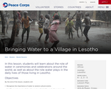
In this lesson, students will learn about the role of water in …
In this lesson, students will learn about the role of water in ceremonies an celebrations around the world, as well as about the role water plays in the daily lives of those living in Lesotho.
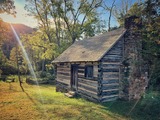
Students will attempt to build a sod house by making choices regarding …
Students will attempt to build a sod house by making choices regarding the construction of their house. Too many wrong answers and the house will collapse! This engaging and lighthearted activity will help students understand the challenges settlers faced while trying to survive on the open prairie.
This virtual field trip from Historic Bath State Site is a fun …
This virtual field trip from Historic Bath State Site is a fun way to learn more about a kid's life in the 18th century. The field trip packet contains ,links to YouTube videos of costumed interpreters demonstrating historic activities, pre- and post-watch content for educators that provide context and engagement, and follow-up activities (games, crafts, and coloring pages). Live Q&A can be booked as part of the field trip as well.
Fort Dobbs has created a series of short videos designed to teach …
Fort Dobbs has created a series of short videos designed to teach students about the settlement of the Northwest Carolina backcountry, the lives of the Native Americans living in and near the region of Fort Dobbs, the life of a North Carolina Provincial Soldier, and North Carolina's role during the French and Indian War. The videos are designed for teachers to use them separately to fit into their own lessons or can be grouped together by theme.
Students can learn about the Fur Trade surrounding Fort Union in Montana …
Students can learn about the Fur Trade surrounding Fort Union in Montana during the 19th Century. They will learn about the economic impact and the relations between the whites and the Native Americans.
This lesson will address the physical and human characteristics of the local …
This lesson will address the physical and human characteristics of the local community. Students will build geographic vocabulary as well as use map skills.
In this lesson, students review the types of communities, examine physical and …
In this lesson, students review the types of communities, examine physical and human characteristics of place, and compare the characteristics of communities.
Students explore the characteristics of the physical environment of communities, including their …
Students explore the characteristics of the physical environment of communities, including their own community, in order to describe and explain variations in the physical environment, including climate, landforms, natural resources, and natural hazards. They also explore these characteristics to identify and compare how people in different communities adapt to the physical environment in which they live. Students also look at excerpts from the journals of Christopher Columbus, whose journeys “opened”the New World to further exploration and settlement, to see how he described the physical environment of the islands where he landed.
In this lesson, students practice using map elements to study location, distance, …
In this lesson, students practice using map elements to study location, distance, and directions and create maps of the local community, comparing differences in human characteristics in rural and urban communities.
Students will investigate patterns in immigration through data tables and data maps. …
Students will investigate patterns in immigration through data tables and data maps. They can also develop their own graphs to view the information in other ways.
This video series is broken up into two-part mini programs which each …
This video series is broken up into two-part mini programs which each include a short video history lesson followed by a second video with a craft activity. These videos are designed to be viewed together to learn about history of Vance Birthplace State Historic Site in the mountains of North Carolina and life in the 1800s.
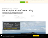
Children and adults can enjoy exploring lighthouses and the maritime history of …
Children and adults can enjoy exploring lighthouses and the maritime history of the United States together through children's literature, everyday objects, and hands-on activities
Students practice using map elements to study location, distance, and directions and …
Students practice using map elements to study location, distance, and directions and create maps of the local community, comparing differences in human characteristics in rural and urban communities.
No restrictions on your remixing, redistributing, or making derivative works. Give credit to the author, as required.
Your remixing, redistributing, or making derivatives works comes with some restrictions, including how it is shared.
Your redistributing comes with some restrictions. Do not remix or make derivative works.
Most restrictive license type. Prohibits most uses, sharing, and any changes.
Copyrighted materials, available under Fair Use and the TEACH Act for US-based educators, or other custom arrangements. Go to the resource provider to see their individual restrictions.