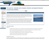
In this lesson, students learn about glacial and volcanic ffeatures by examining …
In this lesson, students learn about glacial and volcanic ffeatures by examining and comparing bathymetric and topographic images of the Sand Point area of Alaska. Students collect map evidence to determine which surface and seafloor features were formed by volcanoes and which were formed by glaciers.
In this lesson the students will become actively engaged by being a …
In this lesson the students will become actively engaged by being a rock in the rock cycle. They will travel to different places and experience the different processes and events that can happen to a rock in the rock cycle. This lesson was developed by Richard Kidd as part of their completion of the North Carolina Global Educator Digital Badge program. This lesson plan has been vetted at the local and state level for standards alignment, Global Education focus, and content accuracy.
The students will use a simulated rock and perform various tasks to …
The students will use a simulated rock and perform various tasks to see what actually happens to rocks and rock fragments as they undergo the transformations within the rock cycle. This lesson was developed by Richard Kidd as part of their completion of the North Carolina Global Educator Digital Badge program. This lesson plan has been vetted at the local and state level for standards alignment, Global Education focus, and content accuracy.
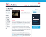
Students explore the geological history of Mercury and the other terrestrial planets, …
Students explore the geological history of Mercury and the other terrestrial planets, Venus, Earth, and Mars. The development of the lesson revolves around GeoHunter, an interactive for planetary geology. They will also learn about MESSENGER, the spacecraft mission to Mercury.
In this series of activities, students explore the features of Mars and …
In this series of activities, students explore the features of Mars and Earth, perform experiments to determine how these features form, and discuss what the features suggest about the history of Mars.
In this series of activities, students explore the volcanoes of Mars in …
In this series of activities, students explore the volcanoes of Mars in comparison with Earth, learn what they tell us about what is happening inside Mars, and review its history.
This unit focuses on earthquakes and volcanoes as the visible signs of …
This unit focuses on earthquakes and volcanoes as the visible signs of plate tectonics. Students progress through a series of investigations using indirect evidence (models) and direct evidence, experiments, active learning experiences, researching using a variety of sources, questions, and assessments. Assessments include: pre-, post and 4 formative assessments.
This unit focuses on the layers of the Earth and what causes …
This unit focuses on the layers of the Earth and what causes movement in the layers. Students progress through a series of investigations using indirect evidence (models) and direct evidence, experiments, active learning experiences, researching using a variety of sources, questions, and assessments. Assessments include: pre-, post and 4 formative assessments.
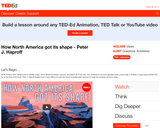
This brief video lesson illustrates and describes the geologic history of the …
This brief video lesson illustrates and describes the geologic history of the Earth and how the North American continent was formed over time through the movement of tectonic plates. Discussion/assessment questions and suggested supplemental resources are also included.
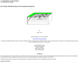
This report describes how to build a model of the outer 300km …
This report describes how to build a model of the outer 300km of the Earth that can be used to develop a better understanding of the principal features of plate tectonics, including sea-floor spreading, the pattern of magnetic stripes frozen into the sea floor, transform faulting, thrust faulting, subduction, and volcanism.
Students learn about the structure of the earth, the movements of its …
Students learn about the structure of the earth, the movements of its tectonic plates, as well as the forces that create mountains, valleys, volcanoes, and earthquakes.
This resource is a compilation of text, videos, and other elements to …
This resource is a compilation of text, videos, and other elements to create a scaffolded 5E learning experience for students. The resource reviews the interior structure of the Earth and forces that occur within the layers of the Earth.
This lesson describes the technique of preparing "GIS-ready" data and shows how …
This lesson describes the technique of preparing "GIS-ready" data and shows how to map that data and conduct basic analyses using a geographic information system (GIS). First, students will download and format near real-time and historical earthquake data from the USGS. Using latitude and longitude fields, they will then plot these data in a GIS. Next, they will analyze patterns by querying records and overlaying datasets. Finally, students will examine earthquake distributions, monitor current earthquake activity, and try to predict where the next big earthquake will occur on Earth.
In this podcast, geophysicist Cynthia Ebinger and Elizabeth Cottrell, director of the …
In this podcast, geophysicist Cynthia Ebinger and Elizabeth Cottrell, director of the Smithsonian Institution’s Global Volcanism Program, talk about the world’s volcanoes and what’s known about the processes that drive them, deep beneath the planet’s surface.
Students move as propagating seismic waves. They record their travel time along …
Students move as propagating seismic waves. They record their travel time along a string of measured length to compute average wave velocities. They then enact an earthquake, and use the time lag between wave arrival times and their computed speeds to determine the position of the epicenter.
No restrictions on your remixing, redistributing, or making derivative works. Give credit to the author, as required.
Your remixing, redistributing, or making derivatives works comes with some restrictions, including how it is shared.
Your redistributing comes with some restrictions. Do not remix or make derivative works.
Most restrictive license type. Prohibits most uses, sharing, and any changes.
Copyrighted materials, available under Fair Use and the TEACH Act for US-based educators, or other custom arrangements. Go to the resource provider to see their individual restrictions.