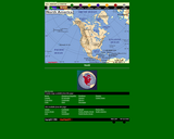
This interactive map of North America contains links to country maps which …
This interactive map of North America contains links to country maps which provide information such as, population, flag, language, capital, industry, and agriculture.
In this lesson, students gain an understanding of North Carolina Native Americans, …
In this lesson, students gain an understanding of North Carolina Native Americans, their way of life and their culture by assuming the role of an archeologist and recreating an artifact that would have been used by Native populations in the pre-colonial period.
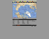
This interactive map of the North Pole contains links to country maps …
This interactive map of the North Pole contains links to country maps which provide information such as, population, flag, language, capital, industry, and agriculture.
This file is the PPT accompaniment for "Teaching Activities for Remarkable Journey." …
This file is the PPT accompaniment for "Teaching Activities for Remarkable Journey." "Remarkable Journey: Founding the Asian Indian Community in North Carolina" is a documentary that illustrates the history, culture, lives, and contributions of Indian-Americans in North Carolina.
This unit will view different cultures from around the world in an …
This unit will view different cultures from around the world in an attempt to see how they developed and to find similarities and differences in the way they developed and the way they lived.
This interactive map of South America contains links to country maps which …
This interactive map of South America contains links to country maps which provide information such as, population, flag, language, capital, industry, and agriculture.
Students examine infrared Landsat images that show the city of Kathmandu in …
Students examine infrared Landsat images that show the city of Kathmandu in different years in order to analyze the urban development of Kathmandu and seasonal changes.
Students examine a Medium Resolution Imaging Spectrometer (MERIS) image that contrasts the …
Students examine a Medium Resolution Imaging Spectrometer (MERIS) image that contrasts the lush vegetation of the Nile delta and the dry sand of the Sahara.
Study guide for the "Remarkable Journey: Founding the Asian Indian Community in …
Study guide for the "Remarkable Journey: Founding the Asian Indian Community in North Carolina," a documentary that illustrates the history, culture, lives, and contributions of Indian-Americans in North Carolina.
This lesson focuses on the importance of geographic features and the abundance …
This lesson focuses on the importance of geographic features and the abundance of natural resources that helped ancient Egypt become the world's first superpower. Students will learn about the geography and resources available to the ancient Egyptians and create a multimedia tour that demonstrates this learning to others.
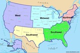
Last summer, I was asked to teach a course in U.S. Geogrphy …
Last summer, I was asked to teach a course in U.S. Geogrphy that would engsge the students, while encouraing development of a final project. So, I created a 24 session course under the guise of a "Travel Plan" and seperated by geogrphic region of the United States. I presnted copies of the travel plan to each student in folder to help them take ownership. During each sesion, the students would view 2-3 short website-based videos that presented the content (state bird, flower, nickname,, etc) with creativity, and would also engage students in identifying historical/geogrphic lanndmarks, colleges/univeristies, professional sports teams, famous indiividuals,, etc associated with each state.Students were highly engaged in identifying the answers to the quesitons in their travel guides, and in learning about the states, and in making connections about the states during American History 1 and 2 from this past year.I've attached copies of the website list I used (Homeschool Pop was great for presenting state information), U.S. Maps, and a lsit of videos from WRAL's "Tar Heel Traveler" series that presents "oof-beat" informnation about North Carolina culture, hsitory, individuals, etc.
A map of Washington DC was created in 1851 - a time …
A map of Washington DC was created in 1851 - a time of relative peace in the United States. Millard Fillmore was president, California had just become a state, and the Capitol building was undergoing an expansion project to accommodate the nation's growing size. By this point, Washington DC had been the nation's capital for about 60 years, although many buildings were newer than that since they had been destroyed in the "Burning of Washington" near the end of the War of 1812. In this lesson, successful students will use a "spyglass map" to explore the 1851 map in detail and compare and contrast with the present day layout and structure of Washington DC.
Students use satellite imagery to learn about flood risks and natural disasters …
Students use satellite imagery to learn about flood risks and natural disasters around the world, taking as an example the floods caused by the Rhone and the Elbe rivers.
No restrictions on your remixing, redistributing, or making derivative works. Give credit to the author, as required.
Your remixing, redistributing, or making derivatives works comes with some restrictions, including how it is shared.
Your redistributing comes with some restrictions. Do not remix or make derivative works.
Most restrictive license type. Prohibits most uses, sharing, and any changes.
Copyrighted materials, available under Fair Use and the TEACH Act for US-based educators, or other custom arrangements. Go to the resource provider to see their individual restrictions.