After the whole class looks at maps and globes and explores legends/keys …
After the whole class looks at maps and globes and explores legends/keys on the map and how symbols represent places/objects/meanings of drawings/details on the map, all students will work together in small groups to collaboratively draw a map of the school. Each group of 3-4 students will create their own map of the school. Then as a class, students will analyze and critique the maps and find the positive attributes of each map. Then higher-level students will take the assignment further by analyzing the layout/structure/plan of the school and deciding what changes would make the school better. They will then work collaboratively to create a map of a “new school” which makes changes to their school to make it more eco-friendly, easier to get around, a better layout for classes, with additions that make it a more enjoyable and functional place to be, etc. This lesson was developed by NCDPI as part of the Academically and/or Intellectually Gifted Instructional Resources Project. This lesson plan has been vetted at the state level for standards alignment, AIG focus, and content accuracy.
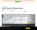
The NC map includes state boundaries, interstate highways, rivers, and the top …
The NC map includes state boundaries, interstate highways, rivers, and the top ten most populous cities in the state. The map is available as a downloadable tiled PDF that can be printed, laminated, and assembled to engage students in group work to learn about their state's geography. The tiled map is a large map that prints out on several 8.5'' by 11'' sheets of paper for easy assembly and convenient printing. The map is also available as a "poster version" that can be printed on a large-format printer.
This interactive map of North America contains links to country maps which …
This interactive map of North America contains links to country maps which provide information such as, population, flag, language, capital, industry, and agriculture.
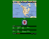
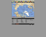
This interactive map of the North Pole contains links to country maps …
This interactive map of the North Pole contains links to country maps which provide information such as, population, flag, language, capital, industry, and agriculture.
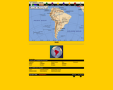
This interactive map of South America contains links to country maps which …
This interactive map of South America contains links to country maps which provide information such as, population, flag, language, capital, industry, and agriculture.
This booklet from the U.S. Department of Interior shows the varied map …
This booklet from the U.S. Department of Interior shows the varied map symbols that represent such features as streets, buildings, streams, and vegetation on a topographic map.
Students will find and explore a local place that is connected to …
Students will find and explore a local place that is connected to trains, such as a train station, a train museum, or train tracks. This is connect with the Smithsonian Museums.
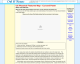
For this resource, students make their own USA by demonstrating their understanding …
For this resource, students make their own USA by demonstrating their understanding of the locations of the major physical features of the United States.
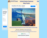
This interactive will allow students to become familiar with the rivers and …
This interactive will allow students to become familiar with the rivers and mountains of the United States. Students will drag and position the features to the correct location on the map.
This lesson will address the physical and human characteristics of the local …
This lesson will address the physical and human characteristics of the local community. Students will build geographic vocabulary as well as use map skills.
In this lesson, students explore why people have settled near water and …
In this lesson, students explore why people have settled near water and the roles that water serves for communities. Students will examine maps to identify large population centers near lakes, rivers, and coastlines. They will then use art supplies to create 3D models which demonstrate how and why a community may depend on a nearby water supply.
No restrictions on your remixing, redistributing, or making derivative works. Give credit to the author, as required.
Your remixing, redistributing, or making derivatives works comes with some restrictions, including how it is shared.
Your redistributing comes with some restrictions. Do not remix or make derivative works.
Most restrictive license type. Prohibits most uses, sharing, and any changes.
Copyrighted materials, available under Fair Use and the TEACH Act for US-based educators, or other custom arrangements. Go to the resource provider to see their individual restrictions.