
This parent guide supports parents in helping their child at home with the 8th grade Science content.
- Subject:
- Science
- Material Type:
- Reference Material
- Vocabulary
- Author:
- Kelly Rawlston
- Letoria Lewis
- Date Added:
- 10/11/2022

This parent guide supports parents in helping their child at home with the 8th grade Science content.

This resource accompanies our Rethink 8th Grade Science course. It includes ideas for use, ways to support exceptional children, ways to extend learning, digital resources and tools, tips for supporting English Language Learners and students with visual and hearing impairments. There are also ideas for offline learning.
In this activity, students demonstrate how water flows on the surface as part of the hydrologic cycle. Students will observe how water gathers in channels and learn how to measure watersheds in terms of magnitude.
In this activity, students use sponges and sand to show how groundwater fits into the water cycle.

In this activity, students remove measured amounts of water from a 5-gallon bucket, simulating the amount of fresh water available on earth.

In this lesson, students will be able to describe the various processes of the water cycle in the Amazon. By performing a skit, they will understand the changes water goes through throughout the water cycle and that this cycle runs continuously with different processes happening at the same time.
Students explore how water moves above and below Earth's surface by using interactive computational models. Then they examine the supply and demand issues around their local water source(s), and they meet a hydrogeologist who introduces students to some of the issues around the sustainability of fresh water sources around the world.
In this lesson, students discover the impact that flooding has on people's lives, and how science and technology can mitigate its effects and help find potential solutions. Working in teams, students design and build a model of a flood-proof home for their family on the fictitious isalnd of Watu. They will consider how flooding affects the whole community and work out where the best place for a home would be.
Students will build a stream table and understand the importance of streams and rivers to the hydrologic cycle. A suite of labs can be done using the stream table, but each can also be a stand-alone exercise.
This short article begins with a definition of groundwater and then focuses on problems related to groundwater in northern India. The Climate Kids website is a NASA education resource featuring articles, videos, images and games focused on the science of climate change.
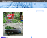
Students build an aquifer model and examine how water gets into an aquifer system.

In this activity, students investigate local biodiversity by placing a transect line outside on the school campus.
Students will explain how groundwater moves through the soil and how it interacts with surface water and demonstrate knowledge about what groundwater is in terms of how it exists in the ground.

This video explores the pros and cons of desalination. A set of discussion questions and post-viewing activities are provided.

In this activity, students make a model watershed and "rain" over the model. In the process, they will learn how water moves in a watershed and why it is important to keep a watershed healthy.
Students learn about drinking water - where it comes from, why and how it is treated before municpal use, and how ocean water distillation may be used to alleviate water shortage problems in some communities. In an associated activity, students will build a device to distill seawater to create drinking water and discover some of the costs associated with producing freshwater from the sea.

In this lesson, students gain a visual perspective on global water distribution and average U.S. water consumption. Students will understand the limited supply of fresh water that exists on the earth and explore the need for not polluting and conserving our fresh water supply.
Students will be completing a tic-tac-toe summary assignment as a formal assessment on the ecosystems found in North Carolina and how water quality effects those ecosystems.

This guide was developed to support teachers in teaching topics with real-world context, and provide them with the background to feel competent and comfortable when teaching about fresh water. The guide includes numerous education features, such as teaching tips and student thinking, that help to connect the content to classroom practice.
This lesson focuses on the use of elevation maps with a focus on Michigan's Muskegon River Watershed. Students are introduced to an elevation profile tool and expected to produce a profile of two other Michigan rivers and examine their watersheds. Success with this lesson will include drawing a simplified profile of one of the rivers as well as labeling two watershed boundaries and the river.