In this activity, students investigate dynamics in the earth's crust that explain …
In this activity, students investigate dynamics in the earth's crust that explain multiple Earth Science phenomena.
GeoInquiries are designed to be fast and easy-to-use instructional resources that incorporate advanced web mapping technology. Each 15-minute activity in a collection is intended to be presented by the instructor from a single computer/projector classroom arrangement. No installation, fees, or logins are necessary to use these materials and software.
Students work collaboratively in small groups to investigate the earthquake cycle using …
Students work collaboratively in small groups to investigate the earthquake cycle using a mechanical model. Students' attention is captured through several short video clips illustrating the awe-inspiring power of ground shaking resulting from earthquakes. To make students' prior knowledge explicit and activate their thinking about the topic of earthquakes, each student develops a definition for an earthquake. Next, small groups of students combine their individual definitions through a collaborative process to create a consensus definition for an earthquake. Using an open-inquiry approach, students then investigate the Earthquake Machine model and compare their group's definition of an earthquake to the behavior of the model. Through this inquiry process students are asked to map the construct of an earthquake to the elements of the mechanical model. A whole-class discussion exploring the ways the model is both like and unlike the actual phenomena of an earthquake follows, while the flow of energy through the mechanical model is emphasized. This explicit mapping process is an important component of the instruction and offers opportunities for students to summarize their findings. All materials needed for the activity can be downloaded from this page.
In this role play activity, students are preparing to be interviewed by …
In this role play activity, students are preparing to be interviewed by the local media about a recent newsworthy quake. The student worksheet walks students through a series of questions to help them prepare. Answering the questions requires making use of the event specific details and the background information provided. However, all answers must be combined with a broader geologic understanding to truly prepare. The activity as provided uses the May 12, 2008 - Sichuan Earthquake as an example. However, the activity could be updated by providing students with similar information from a more recent quake.
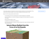
Students examine seismic evidence to determine that the Earth must have a …
Students examine seismic evidence to determine that the Earth must have a layered internal structure and to estimate the size of Earth's core. Note that lesson plan and supporting documents must be downloaded from this website.
Students investigate major earthquakes, tsunamis, and volcanic eruptions that happened in recent …
Students investigate major earthquakes, tsunamis, and volcanic eruptions that happened in recent history. They also consider living conditions, average cost of living, and average income for the areas affected by the disasters. Through group and class discussion, the concepts of social justice are critically analyzed while reinforcing scientific concepts.
Students work collaboratively using data maps to discover plate tectonic boundary processes. …
Students work collaboratively using data maps to discover plate tectonic boundary processes. Data sets used are earthquakes, volcanoes, seafloor age, and topography.
Students will explore seismic hazards for various regions, which can be described …
Students will explore seismic hazards for various regions, which can be described by the likelihood of a certain level of ground shaking for a particular region. Once the seismic hazard is quantified, the seismic risk can be estimated by determining the potential effects of the shaking on buildings and other structures. Students begin by finding the probability of an earthquake of a particular magnitude occurring during different periods in different regions, and comparing these results. Next, students investigate the probability that the ground in each region will shake by a certain amount, during a given length of time and compare those results. Finally, students consider the societal implications of these hazards and how this seismic hazard information might be used to improve community resilience.
Students are introduced to some of the methods scientists use to record …
Students are introduced to some of the methods scientists use to record earthquakes. They obtain data from tables and graphs, carry out simple calculations and draw results on a map.
Earth’s SurfaceGiving us credit when you use our content and technology is …
Earth’s SurfaceGiving us credit when you use our content and technology is not just important for legal reasons. When you provide attribution to CK-12 Foundation, you support the ability of our non-profit organization to make great educational experiences available to students around the world.Our Creative Commons License welcomes you to use our content and technology when you give us attribution. If you have any questions about our policies, contact us at support@ck12.org
Students can investigate how people and nature are changing the landscape over …
Students can investigate how people and nature are changing the landscape over time. The Landsat series of Earth-observing satellites has acquired data for monitoring the planet's landmasses since 1972. Earthshots shows how satellite data are used to track changes in the surface of the Earth. Each Earthshots page features a different location from around the world and explains the changes that the satellite images reveal.
In this lesson, students will run the climate modeling software, Educational Global …
In this lesson, students will run the climate modeling software, Educational Global Climate Modeling Suite (EdGCM), to visualize how temperature and snow coverage might change over the next 100 years. They will begin by running a "control" climate simulation to establish a baseline for comparison. After this first simulation, they will run a second "experimental" simulation. Then they will compare and contrast the changes in temperature and snow and ice coverage that could occur due to increased atmospheric greenhouse gases. Next, students will choose a region of their own interest to explore and compare their modeling results with those documented in the Intergovernmental Panel on Climate Change (IPCC) impact reports. Through working with EdGCM, they will gain a greater understanding and appreciation of the process and power of climate modeling.
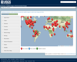
Students wil use Geographic Information Systems (GIS) to investigate earthquakes, volcanoes, and …
Students wil use Geographic Information Systems (GIS) to investigate earthquakes, volcanoes, and population from a local to global scale. The lessons can be used with other data in the Global GIS project to investigate earthquakes in other continents.
Students review their prior knowledge about various types of plate boundaries. Next …
Students review their prior knowledge about various types of plate boundaries. Next students use the IRIS Earthquake Browser to investigate well-known examples of some of these boundaries. Students are asked to pay particular attention to the spatial distribution, rate of seismicity, and depth of quakes in each area. Students then point IEB to a new region and are asked to use the “templates†of seismic evidence they have previously constructed for the primary plate boundaries to argue for what is occurring within the mystery region.
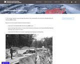
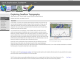
In this module, students will learn how scientists gather data about the …
In this module, students will learn how scientists gather data about the depth of the ocean floor and how these data are displayed to indicate the shape of Earth's ocean basins. Students will explore an illustrated timeline that describes ancient through modern methods used to learn about the seafloor. Then, using GeoMapApp, a freely-available software and data access tool to create visual representations of bathymetric data, they will collect bathymetry data and produce a graph that represents the profile of the seafloor beneath a virtual boat. Armed with a clearer understanding of how the bathymetry data were obtained and how they indicate the shape of the seafloor, students will explore new parts of Earth, using GeoMapApp to create high-resolution profiles and contour maps.
This brief video lecture demonstrates the use of foam blocks to demonstrate …
This brief video lecture demonstrates the use of foam blocks to demonstrate faults, and a deck of cards to demonstrate folds and fabrics in rock layers.
No restrictions on your remixing, redistributing, or making derivative works. Give credit to the author, as required.
Your remixing, redistributing, or making derivatives works comes with some restrictions, including how it is shared.
Your redistributing comes with some restrictions. Do not remix or make derivative works.
Most restrictive license type. Prohibits most uses, sharing, and any changes.
Copyrighted materials, available under Fair Use and the TEACH Act for US-based educators, or other custom arrangements. Go to the resource provider to see their individual restrictions.