This is an activity about image analysis. Learners will create a map …
This is an activity about image analysis. Learners will create a map of the room and discuss the perspectives shown in their drawings and how this relates to satelite images. Participants brainstorm a list of features that might be recognizable in satellite photos, search the Earth Images for these features, and place the images in categories depicting these features. This is activity 2 of 9 in Mars and Earth: Science Learning Activities for After School.
Learners will compare satellite images of Mars and Earth to look for …
Learners will compare satellite images of Mars and Earth to look for similar features. Then they brainstorm a list of forces or events that could have caused some of these features to form on Mars. This is activity 3 of 9 in Mars and Earth: Science Learning Activities for After School.
This resource teaches students where recycled items go, what kinds of recycled …
This resource teaches students where recycled items go, what kinds of recycled products are made from recycled items, and how recycled items are sorted for processing.
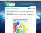
This article points out that there is no one official definition for …
This article points out that there is no one official definition for the Arctic. Then the author identifies definitions ranging from geography to climate to culture and more. Maps and other visuals illustrate the definitions. The author suggests that defining the Arctic can be an example for K-Grade 5 students of the nature and challenges of classification systems. The article appears in the free, online magazine Beyond Penguins and Polar Bears.
In this lesson, students will explore the motives of Christopher Columbus's 1492 …
In this lesson, students will explore the motives of Christopher Columbus's 1492 exploration, the controversy surrounding the changes Columbus's voyages initiated, and the impact of the Columbian Exchange on Native American cultures. Students participate in two simulation activities and a class discussion of these topics.
In this problem-based learning module, students will investigate the following question: Does …
In this problem-based learning module, students will investigate the following question: Does the state of Ohio suffer from "Brain Drain? " If so why is this, where are people going, & what can be done to stop it? If not, what is keeping/bringing people here? After researching and learning about some of the push-pull factors that drove 19th century European immigration to the United States, student groups will be formed in order research, create, and share their findings to determine whether or not Ohio is a "push " or "pull " state. After the launch activity, students will spend the first two days gaining background knowledge on the historical components and content related to the topic. Beginning on Day 4, students will be grouped into teams to begin research and development of the "BIG IDEA " question of: Does the state of Ohio suffer from "Brain Drain? " If so why is this, where are people going, & what can be done to stop it? If not, what is keeping/bringing people here? Once the groups have determined their position on the problem, they will begin researching information to be able to share out their findings.The final products will be presented to an authentic audience consisting of District Administration (i.e., media relations), Local Administration (elected officials), and possibly, local Chamber of Commerce members
Quite simply, “Geography” broken down means “to study the earth” and throughout …
Quite simply, “Geography” broken down means “to study the earth” and throughout your studies in the book, we are going to expand on this definition. If you were to go home and ask your parents about geography they may have studied in school, they might say when they were students they memorized the states and capitals, or major countries in the world. This is only one part of what geography really is however. To study geography is to study where we are in the world; what the world around us is like. It is the study of who lives there and why.
The landmass of North America lies in the Western Hemisphere. It is …
The landmass of North America lies in the Western Hemisphere. It is bordered by the Arctic to the north, the continent of South America and the Caribbean Sea to the south, the Atlantic Ocean to the east, and the Pacific Ocean to the west. The land is rich in resources like coal, natural gas, oil, timber products, freshwater, and an abundance of plant and animal species. Renewable resources such as wind, water, biomass, geothermal and solar are widely used as well.
The area known as Latin America is made up of the region …
The area known as Latin America is made up of the region south of the United States, beginning at the river that separates the U.S. from Mexico, the Rio Grande’, and extending to the southern tip of South America, an area known as Cape Horn.
The region of North Africa and the Middle East lies at the …
The region of North Africa and the Middle East lies at the continental crossroads of Asia, Africa and Europe. At this intersection of the world, all three continents meet here at the Mediterranean Sea. The region extends from the eastern border of Pakistan to the Atlantic coast of Morocco in the west. The region includes many diverse landscapes. It contains rugged mountains, vast deserts, spacious plains and is surrounded by numerous seas. In this unit, you will learn how geography impacts the way people live. You will also discover how culture impacts a person’s perspective.
In the introduction to this book you learned briefly about the five …
In the introduction to this book you learned briefly about the five themes of geography, and previous chapters have covered the geographic themes of Movement (North America), Human/ Environment Interaction (Latin America), and Location (North Africa and the Middle East). This chapter will help you begin to think more about the theme of “place.” Geographers define the study of place as the conditions at a location, or more simply, a study of what it’s like there. If you look back at the chapters on North America, Latin America, and North Africa and the Middle East you’ll notice in the sections on physical geography that this question has really been answered.
Over seven billion (7,000,000,000) people live on planet Earth. South Asia has …
Over seven billion (7,000,000,000) people live on planet Earth. South Asia has over 1,000,000,000 people alone. Geographers determine regions of the world differently, usually based on characteristics that an area shares, such as language, climate, religion or economic similarities. For our purposes, South Asia includes: India, Nepal,
Russia, with over 6.6 million square miles of varied climate and landscape, …
Russia, with over 6.6 million square miles of varied climate and landscape, is the largest country in the world. It is nearly twice the size of the United States or Canada. Covering almost one-eighth of the Earth’s surface, it ranges from the Arctic Circle in the north, to the borders of China in the south, from Europe in the west to the Pacific Ocean to the east. It spreads through two continents and 11 time zones. The Ural Mountains, some of the oldest mountain ranges, stretch from the north to the south. Russia borders more countries than any other and has 12 major seas.
Oceania is an area of the world that has some very unique …
Oceania is an area of the world that has some very unique characteristics. More than one third of the earth’s surface is comprised of the Pacific Ocean and Oceania . In addition to all those islands, Oceania also includes the smallest continent in terms of land size: Australia. You can look anywhere in Oceania and find strong cultural traditions, rich history, and strong geographic features that vary widely depending on where you go.
In the first six chapters of this book you studied a theme …
In the first six chapters of this book you studied a theme of geography and how it related to the region under study. In the last two chapters of this book you studied multiple themes and how they related to the regions. In this final chapter of the book you will put all five themes into practice by studying the most populous of the continents - Asia. More specifically, you will study the themes in practice in East Asia, which includes large countries in terms of land mass and population such as China and Mongolia, as well as smaller nations such as North and South Korea and Japan.
This resource provides global demographic data which includes indicators on the status …
This resource provides global demographic data which includes indicators on the status of women in key areas such as education, employment, and government.
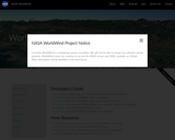
This site features World Wind 1.3, a NASA Learning Technologies application that …
This site features World Wind 1.3, a NASA Learning Technologies application that lets the user zoom from any satellite altitude into any place on Earth. It features 3D Engine, Blue Marble, Landsat 7, SRTM, Animated Earth, MODIS, GLOBE, Country & State Borders, Place Names, Visual Tools and Landmark Set. The user can download World Wind, reference an online manual, post to an online forum, view screen shot examples from various satellites, and read press coverage about World Wind.
This is an encyclopedia entry for the term "ecosystem." An ecosystem is …
This is an encyclopedia entry for the term "ecosystem." An ecosystem is a geographic area where plants, animals, and other organisms, as well as weather and landscape, work together to form a bubble of life. Text for this entry is appropriate for the middle and high school grade levels.
No restrictions on your remixing, redistributing, or making derivative works. Give credit to the author, as required.
Your remixing, redistributing, or making derivatives works comes with some restrictions, including how it is shared.
Your redistributing comes with some restrictions. Do not remix or make derivative works.
Most restrictive license type. Prohibits most uses, sharing, and any changes.
Copyrighted materials, available under Fair Use and the TEACH Act for US-based educators, or other custom arrangements. Go to the resource provider to see their individual restrictions.