This series of activities focuses on the world's oceans and their integral …
This series of activities focuses on the world's oceans and their integral role in weather and climate. In step 1, students will identify the basic circulation patterns of the oceans and evaluate the relationship between ocean currents and trade routes of the past. In step 2, students will analyze climatic data from coastal and inland regions and conduct and experiment on the differing heat capacities of water and air. In step 3, students will locate major port cities of the world and identify ocean currents as potential travel routes. In step 4, students will explore El Nino by analyzing satellite-based data and evaluating weather reports for evidence of its occurrence.
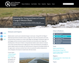
An interactive map based on four decades of satellite images helps residents, …
An interactive map based on four decades of satellite images helps residents, resource managers, and stewards of the land anticipate and plan for coastal change.
In this lesson, students will identify locations around the classroom by programming …
In this lesson, students will identify locations around the classroom by programming a Bee Bot to move to specific locations on a map using positional words.
Using both families and schools as a lens for study, 1st grade …
Using both families and schools as a lens for study, 1st grade students learn about geography, history, economics, and civics with strong connections to the literacy block!
The First Grade text is meant to be explored visually by students …
The First Grade text is meant to be explored visually by students like a traditional “big book”. Some teachers may also want their students to have a copy of the book as a digital text on an iPad, Chromebook, or other digital device. Either way, the way students interact with this book is different from other MI Open Book materials. Each short reading is meant to have some teacher interaction go along with it. We tell you what those are in each section. This chapter also requires construction of a small box. You may use the lid of a ream of paper for creation of this box, or have a sturdier one built for you. This same box will be used across all K-2 books. You may want to have one sturdy one built and shared between teachers.
This website includes information on the geography of France and its Departments, …
This website includes information on the geography of France and its Departments, the population, historical data, and the evolution of the frontiers of France. NOTE: The entire website is written in French.
Please see attached Google Doc for instructions on using Google My Maps …
Please see attached Google Doc for instructions on using Google My Maps to create digital, collaborative maps. This was remixed from a Word document. Nothing was changed except that it is now a Google Doc.
Please see attached Google Doc for instructions on using Google My Maps …
Please see attached Google Doc for instructions on using Google My Maps to create digital, collaborative maps. This was remixed from a Word document. Nothing was changed except that it is now a Google Doc.
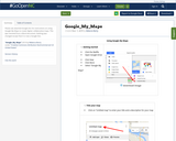
Please see attached Google Doc for instructions on using Google My Maps …
Please see attached Google Doc for instructions on using Google My Maps to create digital, collaborative maps. This was remixed from a Word document. Nothing was changed except that it is now a Google Doc.
Students will use real maps, images, and data to develop an ozone …
Students will use real maps, images, and data to develop an ozone forecast for a particular day in Charlotte, North Carolina. They will then check their forecast against the actual ozone forecast and measurements for that day. Students should already have experience reading weather maps and forecasting weather before doing this activity.
Kindergarten students review the physical and human features of their community and …
Kindergarten students review the physical and human features of their community and how they affect the way people live. Students will participate in a variety of activities in this multiday lesson, including building a model community, exploring and drawing maps, and whole group discussions. A reproducible Parent letter is included with this lesson.
This article gives background information on the Iditarod race in Alaska and …
This article gives background information on the Iditarod race in Alaska and shows how the race can be used in Grades K-5 classrooms to incorporate science, geography and language arts. The author provides links to resources that involve reading expository tests and writing assignments as well as working with real-time data. The article appears in the free, online magazine Beyond Penguins and Polar Bears.
In this classroom activity, students cut apart a plastic soda bottle and …
In this classroom activity, students cut apart a plastic soda bottle and create a planar (polar) and a cylindrical (Mercator) projection to understand the challenges of creating maps of the Earth. The printable handout includes a series of inquiry-based questions to get students thinking about the challenges of mapping a spherical object like the Earth, detailed activity directions and a worksheet that helps students use the activity results to understand how polar and Mercator projections are created and how both distort their subjects.
This chapter on Geography is meant to introduce students to the world …
This chapter on Geography is meant to introduce students to the world around them and begin building foundational geographic skills which will serve them well in later social studies courses. This chapter may look different than many geography units you’ve seen.This chapter was designed with close help from Dr. Phil Gersmehl and his wife Carol, both of whom have extensive geographic pedagogical knowledge and experience. In this chapter we invite students to the world of spatial thinking rather than simply nailing down and exploring the five themes of geography.
This site displays a click-and-zoom map of the US showing forecast temperatures …
This site displays a click-and-zoom map of the US showing forecast temperatures as well as several other meteorological variables, normally updated every hour. Also available are maps showing chance of precipitation, temperature and wind, weather, dew point, weather, precipitation, dew point and cover.
In this activity, students explore the importance of charts to navigation on …
In this activity, students explore the importance of charts to navigation on bodies of water. Using one worksheet, students learn to read the major map features found on a real nautical chart. Using another worksheet, students draw their own nautical chart using the symbols and identifying information learned.
No restrictions on your remixing, redistributing, or making derivative works. Give credit to the author, as required.
Your remixing, redistributing, or making derivatives works comes with some restrictions, including how it is shared.
Your redistributing comes with some restrictions. Do not remix or make derivative works.
Most restrictive license type. Prohibits most uses, sharing, and any changes.
Copyrighted materials, available under Fair Use and the TEACH Act for US-based educators, or other custom arrangements. Go to the resource provider to see their individual restrictions.